Kayaking

Kayaking in Northampton County


Kayak Launches: 

Locations:

  • Morley's Wharf Boat Ramp and Fishing Pier
    2101 Morley's Wharf Rd, Exmore, VA 23350
  • Oyster Harbor Crumb Hill Road & CR 638 Cape Charles, VA 23310
  • Willis Wharf 5201-5307, County Rd 603, Exmore, VA 23350
  • Wise Point Ramp Rd, Cape Charles, VA 23310


Kayak Launch in Oyster
Kayak launch in Oyster, VA. located to the right of the boat ramps.

Kayak launches provide a mechanism to facilitate people getting in and out of their kayaks.  Oyster Harbor, Willis Wharf and Morley's Wharf have kayak launches in Northampton County. The boat ramps and kayak launches are free and open to the public. They are maintained by Northampton County. If you are heading out on the Water Trail in a kayak, these docks are a great place to start. 

Bar to help hold boat steady
A bar helps to hold the boat steady as you load into or unload from the kayak. 

Floating Dock in Willis Wharf
Floating dock in Willis Wharf and sign about the Seaside Water Trail. Photo credit: Jean E. Flynn

Morley's Wharf launch
Morley's Wharf kayak launch and floating docks. 

For more information about boat ramps in Northampton County please visit our Boat Ramps page.  

Note: Wise Point also has a kayak launch that was installed by Northampton County. There is a fee for parking and launching at Wise Point boat ramp. 


Seaside and Bayside Water Trails of Eastern Shore Virginia

Map of water trails of ESVA

Click on the image for a larger view.

For information about visit: Virginia Water Trails


Seaside Water Trail

""
Water trails wind through marshland on the way to the Atlantic Ocean. 
Photo © Gordon Campbell / At Altitude Gallery


The Virginia Seaside Water Trail was developed by the Virginia Coastal Zone Management Program in 2006.  This 100 mile long water trail is a series of day-use paddling routes. There are 37 routes available for all skill levels. 

According to the Virginia DEQ Coastal Zone Management website, "The Seaside Water Trail runs between the Eastern Shore of Virginia National Wildlife Refuge at Cape Charles and Chincoteague Island. Additional trail segments go through Chincoteague National Wildlife Refuge and connect to Assateague National Seashore and the Assateague Canoe Trail. The Seaside Water Trail branches off at Chincoteague Island and ends at the Village of Greenbackville near the Virginia/Maryland state line."

Trail Tips: 

  • Check the weather.
  • Check the tides.
  • Let someone know your plans .
  • Place a 4-foot flag on your kayak so other boaters can see you.
  • Bring emergency supplies of water, food, bug repellent, sunscreen, flashlight, and whistle before you head out.


Barrier Islands


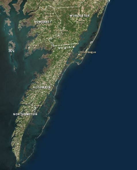
Barrier Islands LandSat

Northampton County's barrier islands are among its most important and unique natural resources. For centuries, they played a major role in the history, economy, and culture of the area. Although there once were small fishing villages and hunting lodges on the islands, today they are uninhabited. Most of the islands are included in the Virginia Coast Reserve, which is an island and salt marsh preserve owned by The Nature Conservancy of Arlington, Virginia. The Virginia Coast Reserve has been designated an International Biosphere Reserve by the United Nations in recognition of the importance and fragility of the ecosystem. Northampton County's islands, together with contiguous islands in neighboring Accomack County, represent the last undeveloped barrier island system on the Atlantic Coast.

There are twelve barrier islands in Northampton County. Hog, Rogue, Cobb, Little Cobb, Ship Shoal, Godwin, Myrtle, Mink, and Smith Islands are mostly owned by The Nature Conservancy. Northampton County Barrier Islands
The Commonwealth of Virginia owns Mockhorn and Wreck Islands. Fisherman’s Island, on the tip of the peninsula, is owned by the Federal government and is part of the Eastern Shore National Wildlife Refuge. The Nature Conservancy has specific rules regarding the use of the islands they own. Most of the islands are open to the public for low-impact, non-commercial, recreational day use (hiking, bird watching and fishing). Motorized vehicles, pets, and overnight camping activities are prohibited. There are also seasonal restrictions to protect nesting birds.

The barrier islands play a number of important roles in Northampton County including: protection from storms as buffers to dissipate the energy of the ocean; economic benefits including commercial and recreational fishing; recreation including fishing, hunting, crabbing, clamming, hiking, boating, and bird watching; and nature study as an educational resource, increasing awareness of the importance and rarity of the island system, and protection of threatened species, offering sanctuary to many species of birds, mammals, and reptiles that are threatened or endangered.

The islands are dynamic in nature; migrating westward over the past 160 years. Because the Virginia Coast Reserve is gaining national and international attention as one of America's last remaining intact barrier island systems, Northampton County benefits through research and educational programs centered around the island system. The University of Virginia has established a National Science Foundation Long Term Ecological Research Center in Northampton County and established its headquarters in the Village of Oyster. Most of the barrier islands are included either in the Virginia Coast Reserve, the Federal National Wildlife System, or the Virginia Natural Areas Program, but even limited development on any of the islands would drastically alter the system scientifically and aesthetically.

In managing the barrier island system, biological diversity has been the priority. It is important to recognize that the island system functions as an interdependent whole. The system includes related natural communities of beaches, dunes, upland forest, extensive salt marshes, bays, creeks, guts, unvegetated wetlands, mainland salt marshes, and any seaside mainland which is part of the watershed.

Source: Northampton County Comprehensive Plan Part II Chapter 4,5,6 Revisions per 9-5-18 meeting 

For more detailed information about the Barrier Islands, please visit our What's a Barrier Island page. 


Chesapeake Bay Gateway and Water Trails

Cherrystone Creek and Chesapeake Bay
Photo © Gordon Campbell / At Altitude Gallery  

"Chesapeake Bay Gateways are the places to experience, first-hand, Chesapeake life and culture. Gateways are the Bay’s hidden treasures — each communicating a unique relationship and story of the Chesapeake. Gateways are parks, wildlife refuges, maritime museums, historic sites and water trails. They are places you can go to volunteer, explore, enjoy, relax, learn or simply renew your spirit...The Chesapeake Bay Gateways tell the stories of the way that water, place, nature and people have been connected over time." 

-From National Park Service Chesapeake Bay Gateways 

Explore Gateways in Northampton County:
Cape Charles Historic District
Kiptopeke State Park
Eastern Shore National Wildlife Refuge

Kayaking near Kiptopeke
Kayakers enjoying  a paddle on the Chesapeake Bay near Kiptopeke State Park
Photo credit: William Dyas


The Chesapeake Bay

"The largest estuary in North America, the Chesapeake Bay Watershed covers 64,000 square miles and includes more than 150 rivers and streams that drain into the Bay. More than 300 species of fish, shellfish and crab species and a wide array of other wildlife call the Bay home. With almost 30 percent of area in agricultural production, the region’s over 83,000 farms generate more than $10 billion annually. The watershed encompasses parts of six states—Delaware, Maryland, New York, Pennsylvania, Virginia and West Virginia—and the entire District of Columbia."

-From NOAA Chesapeake Bay Facts


This video from NASA Goodard is a beautiful visual of the Chesapeake Bay watershed. It uses LANDSAT imaging to give us a complete picture of the largest estuary in the U.S. 

To learn more about the Chesapeake Bay Preservation Act please visit our Wetlands page. 


John Smith Historic Water Trail 

In December of 2006, Congress designated the historic routes of John Smith’s explorations as the first historic national water trail. The trail includes parts of the Chesapeake Bay in Virginia, Maryland, Delaware and the District of Columbia and is approximately 3,000 miles long. Magothy Bay Natural PreserveA portion of the trail runs along the part of the Seaside in Magothy Bay and then along the entire Bayside of Northampton County. 


Visit the National Park Service website for information about the John Smith Historic Water Trail with loads of historical information! 


This video was produced for the National Park Service to promote the Captain John Smith Chesapeake National Historic Trail. Video was set up as a looped display for interpretive centers around the Chesapeake Bay region. 

For more trip ideas visit: Find Your Chesapeake

or Visit the Virginia Water Trails website. 


Kayak smiles


Happy Trails! 

"You must live in the present, launch yourself on every wave, find your eternity in each moment. "
-Henry David Thoreau


Sources: 

http://www.a-npdc.org/water-trails/

Northampton County Comprehensive Plan Part II Chapter 4,5,6 Revisions per 9-5-18 meeting

Virginia Water Trails

John Smith Historic Water Trail

https://oceanservice.noaa.gov/facts/chesapeake.html